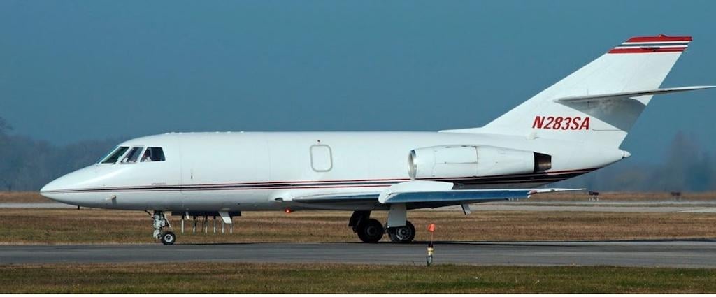
The Dassault Falcon 20 that operated as Sierra West Flight 887.
Making a night approach into an airport with little or no vertical guidance is a difficult task for any pilot. When there are two pilots and they disagree about whether the plane is high or low, the potential for a descent into terrain increases.
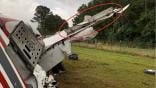
When one of the pilots goads the other one into extending the speed brakes on final approach, an accident is even more likely. These things happened, and much more, when a Dassault Falcon 20 crashed short of the runway at Thompson-McDuffie County Airport (HQU) in Thompson, Georgia, on the morning of Oct. 5, 2021. Both pilots were killed.
The flight was a Part 135 cargo all-nighter operated by Sierra West Airlines. It originated at El Paso, where the crew was based, and stopped in Lubbock, Texas, to add payload before heading to Georgia. The crew was notified of the trip in the late afternoon of October 4, showed for duty at 2150 EDT, and departed El Paso at 2332. The captain flew the first leg and they landed at Lubbock at 0045. After a lengthy delay, they took off again at 0306. The first officer was flying.
The two pilots had flown together recently. Company records showed that in the previous week before the accident they landed at Louisville (SDF), Willow Run (YIP) and Oklahoma City (OKC), as well as Lubbock (LBB) and El Paso (ELP). These are all towered airports with precision approaches and the captain performed most of the landings. The flight to Thompson would be a different matter.
The small airport had no tower and the runway was only 5,514 ft. long. According to a Sierra West flight follower, the Falcon 20 would not be able to land on that runway if it was wet.
The area weather discussion for the Thompson area was to expect “unsettled conditions,” including scattered showers and isolated thunderstorms. The nearest airport to Thompson with a terminal forecast was Augusta Regional Airport (AGS) outside of Augusta, Georgia. The pilots expected 6 mi. of visibility in mist, possibly dropping to 2 mi. temporarily, with a scattered cloud deck at 1,500 ft. They could expect low clouds and drizzly weather as they approached HQU.
In addition, the ILS glide slope to the only runway was NOTAM’d out of service, and the final approach fix was an NDB. The jet was not equipped with modern glass GPS or area navigation displays. There was no DME at or near the field that the crew could use to gage their distance from the airport. They would have to use manual, rule of thumb methods to determine when to start their descent. Without a glide slope, they would have to note their altitude passing the NDB and use the descent rates provided on the approach plate until they could pick up the PAPI lights.
The arrival would require careful planning, good crew coordination, and some precision flying. Instead, the cockpit voice recorder transcript revealed a crew that was angry, disorganized, and distressed.
Pilot’s Discretion Descent
At 0503 the jet was still at its cruise altitude of 35,000. The captain contacted Atlanta Center using the call sign Platinum West 887. He wanted to know if the ILS 10 glide slope at HQU was out of service. The controller was unsure. Four minutes later he gave the flight a pilot’s discretion descent clearance to flight level 240, but added, “platinum west eight eighty seven I’m tryin’ get you stay higher … all the moderate precipitation on your route but uh on the low side we’re showing some moderate heavy extreme precipitation just west of the Atlanta VOR all the way to Atlanta.”
The captain agreed. “Yeah, that’s what our radar is showin.' Yeah we're gonna stay up here as long as we can here. Eight eight seven.”
At 0517 the cadence of an Automated Weather Observing System (AWOS) was recorded, but the quality of the recording was poor. The crew was using handheld microphones and cockpit speakers, not an interphone. The details of the AWOS could not be heard.
A minute later, the captain began a series of firmly worded instructions to the first officer (FO). He began by saying: “You need to stay at three five zero,” and “you can go down but you can’t go up.” Then he said: “fly the plane.” He said it a second time, then said in a stern voice, “I’ve got the airplane.” He didn’t keep control very long, because he soon began berating the FO again.
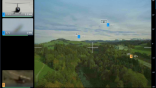
It’s clear that the flight was penetrating an area of turbulence. An NTSB meteorologist provided a display of the WSR-88 air traffic control radar returns at the time, and the graphic shows the flight flew through some heavy “red” returns.
The flight was assigned a heading of 130 deg., and captain commented “he’s probably keeping us out of the worst of it.” However, the FO was having trouble maintaining the heading, prompting the captain to remark, “you’ve flown in badweather before?”
At 0521, a controller turned the flight left to a heading of 110 deg. An argument began, and the captain said: “you fly the damn airplane.” The captain announced the descent checklist was complete, then began reading parts of the ILS/LOC approach plate. Before he could finish, he interrupted himself, again correcting the FO.
At 0525, the flight was descending to 15,000 ft. on a heading of 110 deg., and the captain checked in with Atlanta on another frequency. The controller pointed out that there was moderate-to-heavy precipitation between the Falcon 20 and the field and asked the crew to confirm their intended approach.
The captain replied: “requesting ILS uh runway one zero approach platinum eight eight seven.” The controller said: “stand by for that.” They were less than 20 minutes from landing and the captain was still hopeful that the full ILS was available.
The Falcon 20 descended through a copse of trees with its airbrakes deployed, in Part 2 of this article.

Related Content

Comments